During the Japanese colonization period the administrative districts of Taiwan were divided into different "Hoes"; and after the Retrocession of Taiwan, they were divided into different "Cuns." With the development of the times, Dashe evolved from a size of 6 Cuns during the early Retrocession period to an area of 9 Cuns at present.
Amongst them, Sannaitan Jhuang was a place where many people and local cultures converge, and was also a land lot with the most prosperous commercial activities. Sannaitan Jhuang comprised 4 Cuns, namely Sannai Cun, Guanyin Cun, Cuiping Cun and Shennong Cun. Dashe Jhuang comprised 2 Cuns, namely Dashe Cun and Bao-an Cun. Jhongli Cun had an old name called Linzihbian. Baoshe Cun was originally a place covering two Jhuangs, namely Baoshejia and Wanjinsong. Jiacheng Cun, having the greatest area, comprised the old settlements of Jialieci, Nioushihkeng, Shueisiaozai, Ganzaijhai, Wuci Pond, Beishihlin (including Dachen New Residential Quarter, which was constructed for the Dachen immigrants coming to Taiwan along with the Nationalist Government) and Gutongliao. After merging of Kaohsiung City with Kaohsiung County on Dec. 25, 2010, "Cuns" were changed to be "Villages." Currently Dashe District comprises 9 villages, namely Sannai Village, Cueiping Village, Guanyin Village, Shennong Village, Jhongli Village, Dashe Village, Bao-an Village, Baoshe Village, and Jiacheng Village.
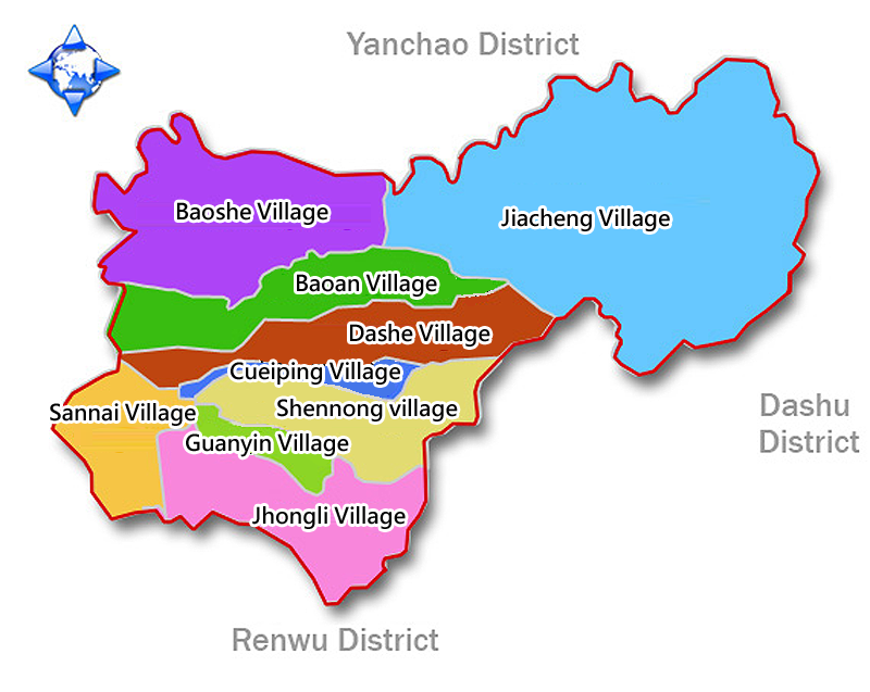
The picture below shows the 9 villages of Dashe District, namely Baoshe Village, Jiacheng Village, Bao-an Village, Dashe Village, Cueiping Village, Sannai Village, Guanyin Village, Shennong Village and Zhongli Village.
- Sannai Village
Sannai Village, located at the southwestern corner of Sannaitan, belongs to a part of Sannaitan. In fact Sannai Cun was originally named after Lady Sannai worshipped by the villagers. As to the original Dashe Township, in the early years the most prosperous cultural, transportation and commercial center, "Sanjiaoyongzi" was located in front of the square of Sannai Temple. At that time the hawkers of the market gathered at this place. Besides, "Sannaitan Small City," located by the side of the temple, was the earliest evening market in Kaohsiung and Pingtung Areas. The whole Village has an area of 125 hectares. After merging of Kaohsiung City with Kaohsiung County, "Sannai Cun" was changed to be "Sannai Village.
- Cueiping Village
The original name of Cueiping Village was "Cueiping Cun," and was located at the north of Sannaitan. It was named after the word "Cueiping" of a local scenic spot called "Cueipingyan of Guanyin Mountain." The settlement, appearing to be a narrow strip, and having an area of 60 hectares, is the smallest village within the territory of Dashe Township. But it was developed earlier and had dense concentration of houses. "Cueiping Cun" was changed to be "Cueiping Village" after merging of Kaohsiung City with Kaohsiung County.
- Guanyin Village
Located at the southeastern corner of Sannaitan, Guanyin Village belongs a part of Sannaitan, and has the most ancient wells. It was an area developed quite early in Dashe Township. Its original name of Guanyin Cun was actually named after a landmark of the original Dashe Township called "Guanyin Mountain." However, Guanyin Mountain was actually located in the original Shennong Cun. In the early years this place was all farmland, with an area of 63 hectares. After merging of Kaohsiung City with Kaohsiung County, "Guanyin Cun" was changed to be "Guanyin Village."
- Shennong village
Shennong Village is located at the east of Sannaitan, and has an area of 220 hectares. In 1950 administrative zoning of this area was done. During the Japanese colonization period, Lizainei Jhuang was the "Fourth Ho." Since Emperor Shennong Temple was located here, this place was named as "Shennong Cun." The original Dashe Township had two major temples, "Cingyun Temple" and "Dajyue Temple" in Guanyin Mountain, both of which were located in the original Shennong Cun. After merging of Kaohsiung City with Kaohsiung County, "Shennong Cun" was changed to be "Shennong Village."
- Jhongli Village
Jhongli Village, originally called "Jhongli Cun" and located at the south of the original Dashe Township, is a settlement between Sannaitan and Renwu. At the end of Qing Dynasty, it was located in Jhongli District of Guanyin, so this area was later named as Jhongli. Its original name was "Linzaibian," which was meant by the side of the woods in Chinese, since there were many trees grown on the ditches surrounding the settlement. The entire village has an area of 220 hectares. In the 13th year of the Japanese Dazheng Era (1924) Renwu Public School was built at the southern rural area of the original Jhongli Cun. Schoolchildren of Renwu Jhuang, living in Nioushihkeng, Wuci Pond and Baoshejia in the northern part, as well as Dawan and Bagualiao in the southern part, all studied at this school. After merging of Kaohsiung City with Kaohsiung County, "Jhongli Cun" was changed to be "Jhongli Village."
- Dashe Village
Dashe Village was originally named as "Dashe Cun." It is located at the northwest of Sannaitan, and has an area of 310 hectares. Originally this Village was mostly farmland. In 1970s the original Dashe Township just encountered the transformation period of the area. Dashe Cun, which was originally remote and rural, all of sudden replaced Sannaitan to become a political, economic and cultural center of the original Dashe Township. The original Township Office, postal office, health center, elementary school, Taiwan Water Corporation, Zhongshan Hall, library, and other institutions were all concentrated on Zihciang Street of Dashe Village. And the National Farmers' Association was just around the intersection and on Sanmin Road. After merging of Kaohsiung City with Kaohsiung County, "Dashe Cun" was changed to be "Dashe Village."
- Bao-an Village
Bao-an Village, located at the north of Dashe Jhuang and originally called Dashe, has an area of 255 hectares. After the Retrocession of Taiwan, this place belongs to a part of the original Dashe Cun. Due to community expansion and the population growth, in 1998 another Cun was branched out, called Bao-an Cun, which was named after "Baoyuan Temple," a local temple of protective god. In Chinese "Bao-an" is meant by asking the various gods of the temple to bless the villagers. After merging of Kaohsiung City with Kaohsiung County, "Bao-an Cun" was changed to be "Bao-an Village."
- Baoshe Village
With its original name called "Baoshe Cun," Baoshe Village is located at the north of the original Dashe Township, and between Jhongzun Ditch and Fengshancuo Creek at the upstream of Dianbao River. Having an area of 470 hectares, Baoshe Village has the broadest flatland area amongst other villages in the original Township. It is geographically in a remote area. In addition, during the Japanese colonization period the farmland in the northeastern rural area underwent land acquisition by Sugar Company for growth of sugar cane, so that its development was slower. In the original Cun, there was Cingfu Temple worshipping Master Cingshuei, and the Temple was the religious center of the original villagers. Besides, a villager called Jhang Rong-Ji, also known as Gong Sheng, returned to his hometown and built Jhangcuo, which was allegedly a large family mansion with three entrances and two protective dragons. Nonetheless, the buildings of the mansion were completely demolished, and hence today the grand occasion of the old years cannot be seen anymore. After merging of Kaohsiung City with Kaohsiung County, "Baoshe Cun" was changed to be "Baoshe Village."
- Jiacheng Village
Originally called "Jiacheng Cun," Jiacheng Village is located at the east of Dashe Township. Its northern border is Fengshancuo Creek at the upstream of Dianbao River. The Village is adjacent to Hengshan Village of Yanchao District. Its eastern border is the watershed of the catchment area at the most upstream of Jhongjhen River, and is just next to Singtian Village of Dashu District. The area of the entire Village is 1,100 hectares, being one-third of the whole District. Jiacheng Village is a Village having the greatest land area, the smallest population and being remotest from the urban area. In the early years after the Retrocession of Taiwan, the two famous Jhuangs of Nioushihkeng and Wuci Pond were co-named as "Niuwu" Cun. In 1963 Niuwu Branch School was approved to be independently established and changed its name to be National Jiacheng School. After that, the villagers thought the name "Niuwu" inelegant. Therefore, in 1966 this Cun was renamed as Jiacheng Cun, having the same name as the school. In recent years the National Highway No. 3 was opened as a broad road. Apart from this, several main roads in the original Cun had also been widened. The original Jiacheng Cun is no longer a remote village under the hill, but had been developed towards the directions of recreation and tourism, which were industries full of hopes and potentials. After merging of Kaohsiung City with Kaohsiung County, "Jiacheng Cun" was changed to be "Jiacheng Village."
|