Geographical features
This district is located in Kaohsiung City, with Dashu District in the east, and Nanzi District in the west, Renwu District in the south, and Yanchao District in the north. Currently, Bus No. Red 60 has been opened for access to Zuoying Station of High Speed Rail (HSR) and to Houjing Station of Kaohsiung Mass Rapid Transit (KMRT), so the district has direct access to provincial roads and the highway. As a result, the local traffic has been extended to all directions. Especially after National Highway No. 10 was officially opened, it even more facilitates the traffic convenience and accessibility of this district.
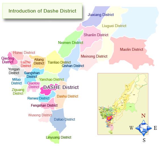
The picture below shows the location of Dashe District amongst the administrative districts of Kaohsiung City. Dashe District belongs to Fengshan Administrative District, with Yanchao District in the north, Dashu District in the east, Renwu District in the south, and Ciaotou District in the west.
The topography of the district is high in the east but descends to the west, and is also high in the north but descends to the south. Since the east part belongs to a low hilly land, half of the western part belongs to a coastal plain (alluvium), being a part of the uplifted coastal plain of the Chianan Plain. In the territory of the district, the originally curved Jhongjhen River has been cut straight, and is far from the metropolitan area. The upstream of the river is within Jiacheng Village of the district, and has very rich ecological landscape. Just because of topographical reason, all the rivers, creeks and ditches of the district flow to the west.
The district seems to have no advantageous climatic and geographical conditions for development. After the several former Village Chiefs had made great effort in developing the district and solving various great problems in the past few decades, the district has turned into a paradise with excellent agricultural, industrial, commercial and tourist development.
According to the latitude, longitude, and topography, the location of the district is introduced as follows:
Latitudinal and longitudinal positions –– The four extreme points, latitude and longitude of the district are:
- The easternmost point:
It is located at the hilly area in the east of Jiacheng Village, and has Dashu District beyond the eastern border. Its location is 120o 24' 13" E and 22o 45' 29" N.
- The westernmost point:
With Jingjian Bridge on Jingjian Road in Renda Industrial District of Sannai Village being the border, it is adjoining Nanzi District of Kaohsiung City. Its location is 120o 19' 33" E and 22o 43' 32" N.
- The southernmost point:
Located at the south of Wanjyue Temple of Jhongli Village and Gaoping Pond, it is bordered by the western hill of Guanyin Lake in Renwu District. Its location is 120o 21' 23" E and 22o 42' 36" N.
- The northernmost point:
Located at the hilly area in the north of Jiacheng Village, it has Yanchao District beyond the northern border (at around the south of "Pochelong" settlement in Yanchao District). Its location is 120o 23' 49" E and 22o 46' 6" N.
The physical geography of Dashe:
This district belongs to the upstream of Dianbao River basin and Houjing River basin. Its northern area belongs to the upstream of Dianbao River basin. Its main stream is at around the junction between this district and Yanchao District. Another tributary of Wulilin River, Jhongzun River (Nioushihkeng branch) flows past the territories of Jiacheng Village and Baoshe Village of the district. This river is sourced from Jiacheng Village of the district. It flows past Wuci Pond and the northern part of the district, flows out of the district, and then connects with Wulilin River at Dongning Village of Nanzi District, and then flows past Ciaotou and Gangshan, and finally flows to the sea in Ziguan District. The southern part of this district belongs to Houjing River basin. The main stream of this river is 26.5 kilometers long. In the southern part of the district, there are Linzibian Ditch, Dabo Ditch and Bengsian Ditch. Water flows down from the hilly area in these three ditches and converges in the western side to form the upstream of Houjing River (also called Nanzikeng River). After water flows out of Dashe and past Ciaotou, it flows to the sea at the junction of Nanzi District and Ziguan District.
In the eastern side of the district is Guanyin Mountain, having Renwu District beyond its border, and having steep hill for climbing at this place. We can always hear birds singing and see flowers blooming here. Similar to Banping Hill in Zuoying District and Shoushan in Kaohsiung City, Guanyinshan also belongs to a famous hilly area in the old Fengshan County. When climbing up high to overlook the views afar, the three peaks are right there, with different rocks and terrains presenting their strange and peculiar shapes. There is also the first barefoot park in Taiwan. It has a large number of animal and plant species, showing the abundant ecological beauty of the park.
Cultural and historical aspect:
In the old days the Han people in the southwestern part of Taiwan always called the village they were living in as "Jhuang" and called the settlement of the indigenous people as "Shè." Therefore, the Taiwanese place names with the word "Shè" may once be the old settlements of the indigenous people.
Dashe Jhuang, located in the western part of Guanyinshan in this district (between Jhongjhen Ditch and Bengsian Ditch), was originally the "Aka" settlement in Dashe under Makatao Branch of the Siraya Pingpu Tribe. After this Shè failed in the resistance against the Dutch in the ancient times, part of the aboriginals migrated to the area around Fangsuozai Port in the southern coast of Dapeng Bay in Donggang Township of Pingtung County. But most of the aboriginals still remained in the original place and ruled by the Hollanders. It was not until the Koxinga Era that the Pingpu tribesmen of "Aka" Shè were gradually "squeezed" out of their original settlement. But the old settlement left was still called by the descendants as "Dashe."
During the Koxinga Era, in order to solve the problem of lack of food, the government actively promoted the policy of asking soldiers to do the work of farmers. Immediately after that, eight orders of garrison farming were promulgated. This district was subordinated to Guanyinshan reclamation zone. In the period of Qing Dynasty, the name and land area of the district changed with different times having different emperors ruling the country. The names were changed from Guanyinshan Jhuang → Guanyin Village → Guanyin Middle Village. At the end of Qing Dynasty the area of Guanyinshan Jhuang covered the land of Guanyin Upper Village, Middle Village, Lower Village, Inner Village, Banping Village, Singlong Outer Village and Inner Village (just today's Yanchao District, Dashu District, Dashe District, Renwu District and Nanzi District, Zuoying District, Gushan District and Yancheng District of Kaohsiung City).
During the Japanese colonization period, the names were successively changed to be Guanyin Middle Village → Nanzaikeng Branch Office → Sannaitan of Renwu Jhuang. In the early days, Renwu Jhuang was subordinated to different administrative districts, and the government affairs were obviously divided into two local factions: one was "Sannaitan" which represented part of the settlements in Guanyin Middle Village; and the other one was "Renwu" which represented part of the settlements in Guanyin Lower Village and Banping Village. Although the local places were added with the Village name of Renwu after restructuring, the Jhuang Office (original address of the Township) was still at No. 587 Sannaitan, which was the old address of the original Dashe Township Office.
During the Japanese colonization period, the administrative affairs of the Jhuang were controlled by the Japanese. At that time the two local factions could still get along with each other in harmony. After the Retrocession of Taiwan, local autonomy was implemented, so that Renwu Jhuang was changed to be Renwu Township. As to political affairs, since Renwu Jhuang was in an inferior situation during voting, disputes between the two local factions arose frequently. At the end of 1949 "Guidelines for Implementation of Local Autonomy in Different Counties and Cities of Taiwan Province and the Regulated Division Methods of Districts" were promulgated. After that, Renwu people, by virtue of their abundant resources, immediately enthusiastically strove for the activity of dividing the Township. Therefore, on May 29, 1951 it was passed after voting in the second meeting of the original Kaohsiung County Conference that the original Renwu Township was divided into two Townships –– the original Dashe Township and Renwu Township.
Before establishment of Dashe Township, the local people always had arguments over the name of the Township. Those people who stressed local culture thought that Sannaitan was a settlement having the largest population in the Township; was a political, economic, cultural and transportation hub of the district; was where the original Township Office was located at; and was famous for miles around, so that the Township should be named as "Sannaitan." But people of the new-wave faction thought that the name of Sannaitan could not be easily pronounced, and the word "Sannai" was inelegant. They suggested that since both the police station and the national elementary school of the district have long been named as "Dashe," it would be better for this Township to be named as "Dashe," which could be read more easily, and sounded better. As to the Jhuang's original name in the district, "Guanyinshan," nobody mentioned it. In the voting, most of the people voted for "Dashe," so this place was called "Dashe."
On Aug. 15. 1951 approval was achieved from the Civil Affairs Department of the Taiwan Provincial Government, and then the original "Dashe Township" was named as such, with its administration officially separated from "Renwu Township." The area was exactly today's area of the original Township. The address of the original Township Office of that time was on today's Sanmin Road. Currently, Dashe District comprises nine Villages –– Dashe, Shennong, Guanyin, Cuiping, Jhongli, Sannai, Baoshe, Jiacheng and Bao-an, with a total area of around 28.23 square kilometers.
In this District, a majority of the residents speak Fujianese, and a minority of the residents speak Hakka. This is a district emphasizing agriculture, industries and commerce. The most well-known agricultural products of the District are jujubes and guavas. Besides, this district is the largest dairy farming area in Kaohsiung City. The production volume of milk in this district is the top of the whole city. "Guanyin Mountain" is a famous tourist spot in the Southern Taiwan. Although many factories have been built in "Dashe Petrochemical Industrial District," a large number of employment opportunities are created for local people. With the opening of the National Highway No. 3, as well as the establishment of the neighboring I-Shou University, Shu-te University and E-da Hospital, tens of thousands of consumers have been brought to the district mainly because of the convenient living and shopping district here. The original commercial center, mainly the old settlement of Sanjiaoyong, has been replaced by the peripheral road of Guanyin Mountain, i.e. Jhongshan Road. Now the culture of the district is busier and more diversified than before. Due to such local development, Dashe District has just become a wonderful place for development of industries, commerce, agriculture and tourism.